A territory at risk: anticipating the next major flood in Île-de-France
The Île-de-France region is one of the areas most exposed to flood risk in Europe. The flood of 1910, a major historical event that paralyzed Paris for several weeks, is now the benchmark for risk management for public authorities. Although this episode is now a thing of the past, its scenario remains entirely plausible today: studies conducted by government agencies and the EPTB (Etablissement Public Territorial de Bassin) Seine Grands Lacs remind us that the region is still susceptible to flooding of equivalent or even greater magnitude.

The Seine and Marne river basin covers nearly 19 departments, with a population of over 12 million and a significant number of major infrastructure facilities: transport networks, healthcare facilities, schools, water and energy networks, etc. In this highly urbanized environment, the consequences of another flood would be considerable, both for the population and for the economy. Added to this is another often overlooked risk: the overflowing of groundwater, which can occur several weeks after a flood and cause severe flooding and lasting damage to buildings.
Managing these phenomena requires tools capable of modeling, anticipating, and representing the effects of such events: changes in water levels, runoff dynamics, impact zones, and human and material vulnerabilities. With this in mind,EPTB Seine Grands Lacs sought to thoroughly modernize its simulation and decision support system.
In the current context of climate change, where hydraulic risks have increased, public authorities have high expectations. The Prefect of the Île-de-France region, the Police Prefect, the fire and rescue services, and all local authorities need reliable and robust tools to prepare, coordinate, and manage an operational response in a timely manner. The aim is not only to map flood-prone areas, but also to provide an accurate spatio-temporal view of the evolution of a flood, the time available to organize evacuation, and the number of people likely to be affected.
EgoSeine is part of this approach:
- provide an interactive and operational tool to help authorities and citizens understand the risks
- prepare for crisis situations
- and prepare for its management in the event of rising water levels.
By combining geographic data, hydraulic models, and demographic information, the platform provides a clear, actionable, and predictive assessment of flood risk across the entire Île-de-France region.
EgoSeine: a modern hydraulic modeling tool
In early 2024, EPTB Seine Grands Lacs entrusted Magellium Artal Group with the consolidation and functional development of the EgoSeine project, as part of a multi-year agreement extending until 2028.
This project marks a major milestone in the development of a practical, secure, and sustainable tool for flood risk management across the Île-de-France region.
Since April 2024, Magellium Artal Group has been assisting EPTB Seine Grands Lacs in consolidating the base architecture, restructuring data, and enhancing hydraulic models in order to strengthen the robustness and performance of EgoSeine.
This reconstruction was carried out using an agile method, which made it possible to initially deliver a first version that could be used by the client. The implementation and effectiveness of this first version led the Prefect of Paris to approve EgoSeine as the official reference tool.
Technologically, EgoSeine relies on several GIS tools and technologies:
- The system is based on the ArcGIS Suite (Portal, ArcGIS Server 11.5, AGOL, ArcGIS PRO 3.5, Experience Builder, etc.), which allows data to be structured, processed, and shared with field workers.
- The database is stored in PostgreSQL.
- The 3D models are based on high-resolution meshes in order to accurately represent the topography of the Paris region.
- Tools such as FME complete the architecture for cleaning, transforming, and integrating data from multiple sources.
Thanks to these solid foundations, EgoSeine now offers a responsive and scalable platform capable of integrating new flood scenarios, new hydraulic algorithms, and additional data layers. The tool serves as a hub connecting hydraulic expertise, geospatial data, and the operational needs of decision-makers and public actors.
EgoSeine thus becomes not only an analysis tool but also a crisis planning and management system. It gives institutions the means to anticipate a major event, make informed decisions, and prepare the population to respond appropriately in the event of a major flood.
Different scenarios to understand, anticipate, and act
EgoSeine uses a flood scenario approach. Designed to help public authorities understand flood dynamics, the EgoSeine project measures the impacts of flooding and enables them to prepare appropriate responses for different levels of severity. The aim is not only to represent flood-prone areas but also to provide an accurate spatio-temporal reading of the event, from the first rises in water levels to the most critical phases of the crisis.
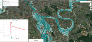
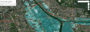
The platform therefore offers interactive mapping of exposed areas, including specific data and recommendations tailored to each territory. Users can:
- Visualize changes in water levels over time,
- Analyze the spread of flooding neighborhood by neighborhood and cross-reference the information with data on the various infrastructure present (public transportation, schools, healthcare facilities, etc.).
EgoSeine provides, for example, the coordinates of a given location, the duration of water presence, the water level on the selected day, etc. This analysis makes it possible to anticipate the most vulnerable areas and identify priorities for action.
The first major scenario integrated into EgoSeine concerns the reproduction of the 1910 flood transposed onto the current structure of the Paris region over a period of sixty days. This reference scenario makes it possible to measure the potential impact of a historical event in a territory that is now much more urbanized and densely populated. The simulations highlight water levels that could reach 5 meters in certain areas, as well as the gradual rise and fall of the waters. This information is now essential for organizing evacuations and ensuring the continuity of public services.
In addition, EgoSeine incorporates a simulation model of groundwater rise and overflow, with a horizon of up to 240 days. This phenomenon, often underestimated or ignored by the general public, can cause delayed flooding, occurring several days, weeks, or months after the main flood. The swelling of groundwater levels, combined with rainwater runoff, causes new flooding that can affect buildings, underground networks, and sensitive infrastructure. Taking these dynamics into account enhances stakeholders' ability to anticipate the effects of a major hydrological event.
To inform these scenarios, EgoSeine draws on a set of data:
- Topographic data models (DTMs),
- Demographic information from the 2020 INSEE census,
- Data relating to various infrastructure: schools, healthcare facilities, facilities for the elderly, and transportation networks (provided by external web services).
This data allows for the precise quantification of exposed populations and critical infrastructure requiring protection.
This scenario-based approach gives EgoSeine an operational dimension. The platformmakes it possible to estimate the number of people to be evacuated, identify the time available before the water arrives, and prepare mass evacuation plans adapted to the realities on the ground. It is also an educational tool that facilitates decision-makers' understanding of the risks and contributes to the preparation of crisis management actors.
Finally, EgoSeine offers an open API (Application Programming Interface) for major operators and technical stakeholders, such as transport or energy network managers. This openness allows flood scenarios to be integrated into third-party systems, promoting coordination between the various stakeholders and more effective crisis management.
A platform designed to last and adapt
Designed from the outset as a scalable platform, EgoSeine is part of a long-term vision to serve public stakeholders involved in flood risk management.
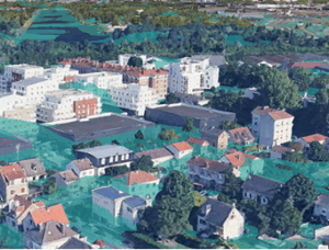
The multi-year contract allows for continuous improvement. By the end of 2026, the platform will incorporate a 3D digital twin of the territory, enhancing its representation and analysis capabilities.
This extension will provide an immersive visualization of the impacts on urban areas, infrastructure, and populations, facilitating understanding of territorial issues. EgoSeine will also integrate new flood scenarios to broaden the range of situations analyzed and better prepare decision-makers for events of varying nature and intensity.
Other developments are also being considered, including the integration of 3D data from Google Earth, onto which flood layers will be superimposed, as well as colorization of Lidar data and 3D modeling of the four large reservoir lakes and their dikes belonging to the EPTB Seine Grands Lacs.
Presented at various trade shows such as GeoDataDays 2025 and Salon ESRI France 2025, the EgoSeine project is gradually establishing itself as a benchmark platform for flood modeling and decision support for risk management in mainland France and overseas territories.
Through EgoSeine, Magellium Artal Group brings together all of its expertise in geographic information systems (GIS), 2D/3D modeling, and software development, demonstrating its ability to design robust, scalable, and sustainable solutions for risk management and territorial security to help public institutions prepare for the major environmental challenges of the coming years.
Want to know more?
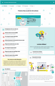
EgoSeine is also part of a broader initiative to raise awareness and prevent flood risk. The API developed by Magellium Artal Group allows EgoSeine data to be displayed on a website aimed at the general public: EpiSeine.
This interface, also available as an app, allows users to enter an address or use their smartphone's geolocation to find out the estimated water level at peak flood stage, the impacts associated with that location, the expected evacuation time, and the right steps to take.
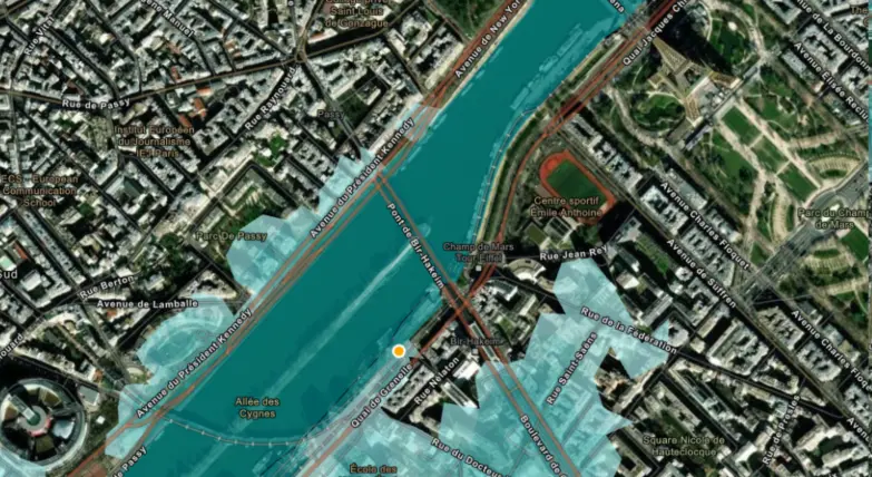
For example, in the Maisons-Alfort area, simulations indicate that water levels could reach one meter on the roads, with major consequences for the networks: interruption of electricity and gas supplies, sewage backups, and the risk of drinking water supply cuts.